
Site and Vision
WHY HERE?
- Stockport is preparing a new Local Plan which will guide development across the Borough which is expected to release Green Belt Land for housing.
- The site was previously included as a proposed housing allocation within the draft Greater Manchester Spatial Framework that was published in 2016 as a site suitable and appropriate for new housing.
- The proposals can provide a positive opportunity to complement Woodford in a comprehensive way.
WHY NOW?
Stockport’s annual housing requirement, set by the Government, has risen by nearly 80% to 1906 homes per year. Whilst development on previously developed land is a priority; there are not enough brownfield sites to meet Stockport’s pressing need for new homes and supporting infrastructure.
HAS REGARD BEEN GIVEN TO THE WOODFORD NEIGHBOURHOOD PLAN?
We’ve considered the Neighbourhood Plan in our research and assessment, and taken on board principles around protecting natural assets, supporting biodiversity, improving public rights of way, protecting heritage assets, and introducing sustainable drainage. These form important parts of our proposals.
OUR VISION IS TO CREATE A FLOURISHING COMMUNITY WITH A LASTING LEGACY. OUR PROPOSALS INCLUDE:

HOMES FOR EVERY STAGE OF LIFE
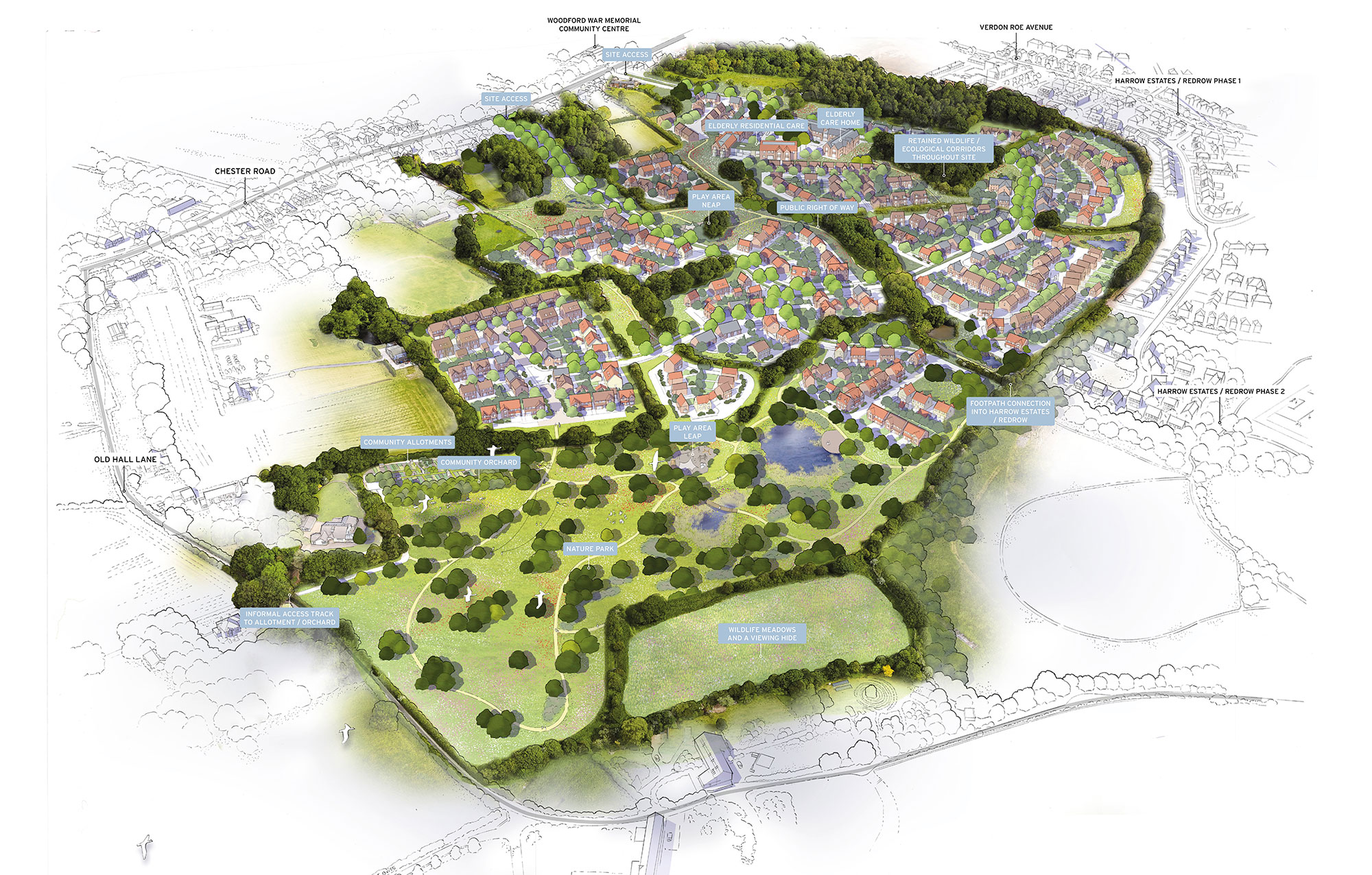
A wide range of high-quality, energy-efficient homes, with up to 50% affordable housing to meet Stockport’s needs. The plans also include specialist accommodation for older people, with a care home and independent living apartments, alongside unique self-build plots.

A GREEN AND NATURAL ENVIRONMENT
A landscape-led design providing a significant amount of valuable open space. This includes a new Nature Park, two play areas, community allotments, and an orchard. We will integrate retained ponds, trees, and hedgerows with significant new planting to enhance wildlife habitats and deliver a biodiversity net gain.

NEW CONNECTIONS
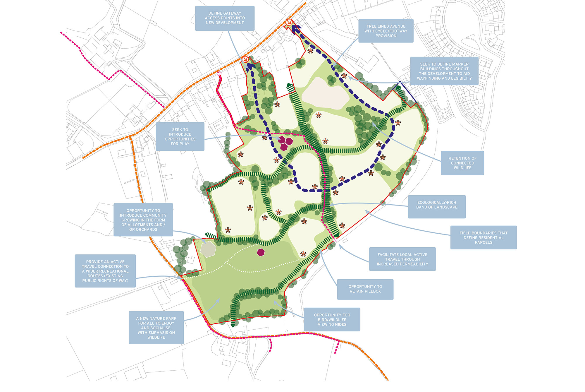
A new network of on-site pedestrian and cycle routes, retaining and enhancing the existing Public Right of Way. We are also exploring opportunities to extend cycle routes along Chester Road and are in discussion with stakeholders about potential public transport improvements.

A CONSIDERED APPROACH
A number of technical studies are underway to help shape the evolving masterplan.


ECOLOGY AND LANDSCAPE
The design is guided by a Landscape and Visual Impact Assessment (LVIA) to protect local character. A large number of mature trees, hedgerows, and all ponds will be retained. The more open southern part of the site provides an ideal location for the proposed Nature Park.

HERITAGE
There are no designated heritage assets on the site. Careful consideration has been given to the setting of three Grade II Listed Buildings on nearby Chester Road, and a historic, non-designated pill box within the site can be retained.

FLOODING AND DRAINAGE
The site is in Flood Zone 1 (lowest probability of flooding). We will use a Sustainable Drainage System (SuDS), allowing rainwater to be managed naturally on-site. This improves the current situation by reducing surface run-off.

TRANSPORT ASSESSMENT
A detailed Transport Assessment has been carried out to fully understand the impact of new traffic on the local road network. This will allow us to identify any measures needed to manage traffic flow.
A full range of technical assessments will be provided as part of the outline planning application.

A WELL-CONNECTED NEIGHBOURHOOD
Our vision is for a sustainable community that encourages walking and cycling. The site is well-located, within walking and cycling distance of local services and close to existing bus stops and local train stations.
The principal vehicle access is proposed from Chester Road. A detailed Transport Assessment is being prepared to assess the impact of new traffic on the local highway network.